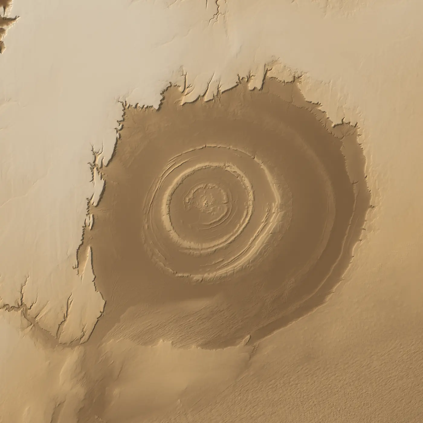
Is It Atlantis? Put Plato's Rings on the Eye of the Sahara
Plato gave exact measurements for his lost city. A 40-kilometre ring of rock in Mauritania looks uncannily like them. Here are both, in 3D, at true size. Drag the rings and get an honest score.
About 13 min16 sources3D terrain
Plato didn't just describe Atlantis. He measured it: an island five stades across, then rings of water and land three, two and one stades wide, and a canal fifty stades to the sea.1
In the Sahara there is a bull's-eye of rock rings 40 kilometres wide.46 Put the two together yourself.
Drag to turn it. Pinch or scroll to zoom. Tap or click a stade to resize the rings. Or drag the outer gold ring. On a phone, tap the 3D view first so the page keeps scrolling; Done hands it back.
3D is not available on this device, so the flat map stays. Every button still works on it.
Shape fitStade length19%185 m (Athens)chance ≈12%✓ A surviving Greek track length
Plato’s sizes at a 185 m stade: rings and island 5.0 km across, city wall 23.5 km. These are not Richat measurements.
Stade
These are Plato’s rings at true size for the Athens track. Press a button, or pick a stade.
Layers
How we measured and how we score
Our measurement. Copernicus GLO-30 elevation, resampled to a 100 m grid over a 66 × 66 km window. Local relief = height minus its 1.2 km average. We searched for the centre that makes the ridges most concentric. Along 72 rays (every 5°) we marked ridge crests standing at least 6 m above the ground within 1.5 km either side.
Shape fit % = the share of Plato’s six ring boundaries × 72 directions where a measured crest lies within 8% of the radius or 250 m, whichever is larger. A perfect concentric test pattern scores 100%. Random ridges at the same density score about 12% at real stades and about 42% at 2,038 m, because big rings catch more ridges by chance.
Chance baseline = the same score for random ridges: each direction keeps its number of crests, placed at random distances up to 30 km (120 trials per stade). Every fit % in the tool is shown beside the chance score for that stade.
Full method: MEASUREMENTS.md, kept with the build.
The eye in the desert
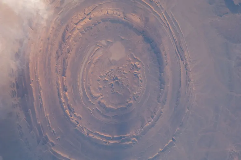
NASA's Gemini IV astronauts photographed it from orbit, and helped make it famous as the Eye of the Sahara.6 Its official name is the Richat Structure. It sits on the Adrar Plateau of Mauritania, about 500 kilometres from the Atlantic coast.6
From orbit it looks like a target. On the ground it is a set of low ridges of hard quartzite, with softer rock worn away between them. Geologists call ridges like these cuestas.46
It is not a crater. The first guess was an asteroid impact, because impacts make circles.6 Later work showed a dome of rock pushed up from below by molten rock and then planed flat by erosion.4 The newest study dates the ring-shaped bodies of gabbro, a dark rock that cooled from magma underground, to between 230 and 200 million years ago, with the doming about 100 million years later.5
That is the geology, and it is solid. It does not explain why the place keeps pulling people in.
The Richat Structure from the International Space Station, 17 December 2011 (ISS030-E-12516). NASA.
What Plato wrote
Plato wrote the Atlantis story in two dialogues, the Timaeus and the Critias, about 2,400 years ago.215 He says the tale came from Egyptian priests by way of Solon, the Athenian lawgiver.2
The detail is unusual. Poseidon made "two of land and three of water, which he turned as with a lathe," each ring "equidistant every way from the centre."1 Then come widths in stades: three, three, two, two, one, and an island five across.1
A stade was 600 Greek feet, the length of a running track, and real tracks survive. At Olympia the track is 192.27 metres; at Athens, 184.96; at Miletus, 177.36.3
At those lengths, Plato's whole ring system, all five rings and the island, is about 4.8 to 5.2 kilometres across. His outer city wall, 50 stades beyond the largest ring, makes a circle 22.5 to 24.4 kilometres wide (our arithmetic from his numbers and the real tracks).13
Plato also tells you he had doubts. Of the giant ditch around his plain, he says it "could never have been artificial. Nevertheless I must say what I was told."1
The test
Now press "Plato's true size." The rings shrink to a bright coin in the middle of the eye. At any surviving track length, his rings and island together are about one-eighth the width of the structure.
Press "Make it fit." The rings stretch until they line up with as many ridges as they can, and the stade they need shows in the corner. Our measurement: the best stretch needs a stade of about 2,038 metres, more than ten times the Olympic track, and even then the rings sit on ridges 48% of the time, where rings dropped at random score about 42%. That is not a fit. It is chance wearing a costume. At the real track lengths the match is 19 to 21%, against about 12% for random rings: a little better than luck, and a long way from a map.3
Press "Fit the city wall." This is the comparison that holds up best, and only just. At real stades the wall circle is 22 to 24 kilometres wide, a big ring inside a 40-kilometre dome. Our measurement: at the shortest surviving track, Miletus at 177 metres, 54% of the wall lands on a ridge, against about 37% by chance. Lengthen the stade to Athens or Olympia and it falls to 38% and 28%, no better than luck. One stade out of three, one ring out of seven. Hold that loosely.3
Then the hard fails, stated plainly.
Plato's canal ran fifty stades, roughly 9 kilometres, from the sea to the outer ring.1 The Richat is about 500 kilometres from the sea.6
Plato's Atlantis was an island "larger than Libya and Asia put together," in front of the Pillars of Heracles.2 The Richat is inland Africa.
Plato's island vanished "in a single day and night of misfortune."2 The Richat is still there.
And the Richat's rings are natural, carved by erosion from rock domed up about 100 million years ago.5 Plato's were cut by a god, then bridged and tunnelled by kings.1
Plato’s Text: 12 tests
Each card has Plato’s line and a verdict. Tap or click “Show the sources” for the Richat evidence. On a phone, swipe sideways.
Match
Rings round a centre
“two of land and three of water, which he turned as with a lathe” (Criti. 113d)1
The Richat: The Richat is a set of nested quartzite ridges, cuestas, with softer rock worn away between them.46
Partial
Ring proportions
Island 5 stades across; rings 3, 3, 2, 2 and 1 stade wide (Criti. 115d–116a)1
The Richat: Our measurement: at the Miletus, Athens and Olympia track lengths the rings sit on ridges 19% to 21% of the time (chance ≈12%): a little better than luck. The best stretch at any scale needs a stade of about 2,038 m and scores 48% (chance ≈42%): not a fit.
The Richat: At the Miletus, Athens and Olympia track lengths that is 4.8 to 5.2 km, about one-eighth of a structure 40 km wide (our arithmetic).34
Partial: 177 m only
Walled city size
The outer wall, 50 stades beyond the largest ring (Criti. 116a)1
The Richat: At real stades the wall circle is 22.5 to 24.4 km wide (our arithmetic). Our measurement: at 177 m, 54% of the wall lands on a ridge (chance ≈37%). At 185 m it is 38% (chance ≈38%) and at 192 m 28% (chance ≈39%): no better than luck.
Fail
Canal to the sea
A canal 50 stades long, from the sea to the outer ring (Criti. 115d)1
The Richat: Fifty stades is roughly 9 km. The Richat is about 500 km from the Atlantic coast.6
Fail
An island in the Atlantic
An island “larger than Libya and Asia put together”, in front of the Pillars of Heracles (Tim. 24e)2
Case for: Some readers take “island” to mean a coast or region. Claim
Case against: Plato’s own words: “larger than Libya and Asia put together.”2
The Richat: The Richat is on the Adrar Plateau, inland Africa.6
Fail
Sank in a day and a night
“in a single day and night of misfortune” (Tim. 25d)2
The Richat: The Richat is still there.
Contested
A plain 3,000 × 2,000 stades
An oblong plain, 3,000 by 2,000 stades (Criti. 118a)1
Case for: A plain that size around the Richat would reach far across the Sahara; readers who favour the Richat point to the open country around it. Claim
Case against: Plato’s numbers make the plain hundreds of kilometres long at any real stade (our arithmetic).13
The Richat: At the Athens track length that is about 555 × 370 km (our arithmetic). The drawing below puts it beside the 40 km Richat. You judge.
Natural
Built rings or natural ones
Rings cut by a god, then bridged and tunnelled by kings (Criti. 113d–115e)1
The Richat: The Richat’s rings are natural, carved by erosion from rock domed up about 100 million years ago.5
Match: water, not sea
Water at Plato’s date
Plato’s war, 9,000 years before Solon (Criti. 108e)1
The Richat: At the Richat, torrential gravels with brackish-water shells are dated 15,000 to 7,730 years ago, a window that includes Plato’s date. That is streams, not a sea or a harbour.7
The Richat: An elephant is engraved on a rock at Tililit, on the Richat. Its age is not known.11
Open
Remains of a city
Temples, harbours, docks and bridges (Criti. 115c–117e)1
The Richat: No city has been reported. The outer ring holds huge numbers of stone tools, and central Mauritania has at least 12,000 funerary monuments; very few are excavated and dated.71012
Plato’s text: 2/12 match. Partial 3 · Open 1 · Contested 1 · Natural, not built 1 · Fail 4.
The man who put them side by side
In September 2018 the YouTuber Jimmy Corsetti, whose channel is Bright Insight, published a video on the lost city of Atlantis.16 He laid Plato's description next to the Richat and called it "the most likely location for the lost city of Atlantis."16 The video has passed five million views.16
He deserves credit for one thing nobody can take away. He made millions of people look hard at a place most had never heard of. The tool above is the next step: the same comparison, with the scale switched on.
Where it gets interesting
Here is where a quick debunk stops too early. Plato's map fails at the Richat. Plato's date is another matter.
His priests put the war 9,000 years before Solon's day.12 Solon gave Athens its laws in 594 BC.14 Counted from there, Plato's date lands near 9600 BC, about 11,600 years ago (our arithmetic).
That was not a quiet moment on Earth.
The Sahara was wet. Across North Africa the African Humid Period brought expanding lakes, rivers and grassland. A cold, dry snap called the Younger Dryas interrupted it, and wet conditions returned around 11,700 years ago, within about a century of Plato's date.8
At the Richat itself, water ran. Torrential streams laid down gravel, with the shells of brackish-water molluscs in it. Eleven radiocarbon dates put those deposits between 15,000 and 7,730 years ago.7
The sea was rising. At the height of the last Ice Age, sea level stood about 134 metres lower than today. The main melt ran from about 16,500 to 8,200 years ago, with a slower stretch during the Younger Dryas.9 A rise that size puts the old shorelines far out under today's sea (our inference).
And people were building. At Göbekli Tepe in Turkey, hunter-gatherers raised megalithic enclosures between 9,600 and 8,200 BCE.13 Our record: /r/GOB-TEP.html.
None of this puts a city at the Richat. It does mean Plato's number, whatever its source, points at a real hinge in history: rising seas, a greening desert and monumental stone raised by hunter-gatherers.
Plato’s date on the real timeline
Plato’s date: c. 9600 BC (our arithmetic: 594 BC + 9,000 years), about 11,600 years ago.114
What the ground still hides
The Richat is not empty of people. It is crowded with their traces.
Hand-axes and older chopping tools lie in huge numbers in its outer ring, made on the spot.7 The prehistorian Robert Vernet calls it possibly the largest concentration of pebble tools, the simplest worked stones, in the whole Sahara.10 The study of the sediments suggests more lie buried under the outer plains.7
On a rock at Tililit, on the Richat, someone engraved an elephant. The researchers who recorded it called it "the most carefully made representation of an elephant" they knew in the region (as quoted by Vernet; our translation).11 Its age is not known; the same rock carries styles from several periods.11
Plato, for what it's worth, gave his island "a great number of elephants."1
Then there are the tombs. In central Mauritania Vernet counts at least 12,000 funerary monuments, not counting the simple cairns. "Very few have been described," he writes, "and even fewer excavated and dated."12
Vernet put the problem in one line. It is "incomprehensible," he wrote, that the region's archaeological promise has not produced more, "even though the Richat is not hard to reach" (our translation).10
The question the rings leave
Plato's own Athens shows how he thought about time. He describes its old soil washed into the sea by "many great deluges," leaving "only the bones of the wasted body."1
His Atlantis is a story about power. Its kings were children of a god, and their fall began, he says, when "the divine portion began to fade away" and they grew "full of avarice and unrighteous power."1 The numbers may be his invention. The idea under them, that a world was drowned and its people forgot, has real coastlines behind it. The Ice Age shore stood 134 metres below today's.9
So drag the rings one more time. They don't fit. Then look past them, at a country where thousands of tombs sit undated in the sun, and ask who was standing here 11,600 years ago, watching the water come back.
Share your honest fit: the card shows your rings on our hillshade, the stade you used and its realism tag, and Plato’s text score. The link reopens your exact view.
Sources
Plato, Critias, tr. Benjamin Jowett (1892), Project Gutenberg #1571; Greek checked against Burnet's text on Perseus (Criti. 108e, 111a–b, 113c–d, 114e, 115d–116a, 117e, 118a–e).
Plato, Timaeus, tr. Benjamin Jowett, Project Gutenberg #1572 (Tim. 21e–25d).
Dieter Lelgemann, "Recovery of the Ancient System of Foot/Cubit/Stadion – Length Units", FIG Working Week, Athens, 2004, WSHS2.1, Table 5 (racetrack lengths). fig.net.
G. Matton, M. Jébrak and J. K. W. Lee, "Resolving the Richat enigma: Doming and hydrothermal karstification above an alkaline complex", Geology 33(8):665–668 (2005), doi:10.1130/G21542.1 (abstract).
E. H. Abdeina, F. Jourdan, G. Chazot, H. Bertrand and B. Le Gall, "How old is the Eye of Africa? A polyphase history for the igneous Richat Structure, Mauritania", Lithos (2024), doi:10.1016/j.lithos.2024.107698 (abstract).
NASA Earth Observatory: "Richat Structure" (Image of the Day, 29 Apr 2018); "The Eye of the Sahara" (10 Jul 2022); "Eyeing the Richat Structure" (16 Apr 2026). science.nasa.gov.
P. Giresse, O. Sao and H. de Lumley, "Étude paléoenvironnementale des sédiments quaternaires du Guelb er Richât (Adrar de Mauritanie)…", L'Anthropologie 116(1):12–38 (2012), doi:10.1016/j.anthro.2011.12.001 (abstract, em-consulte).
J. A. Holmes and P. Hoelzmann, "The Late Pleistocene-Holocene African Humid Period as Evident in Lakes", Oxford Research Encyclopedia of Climate Science (2017), doi:10.1093/acrefore/9780190228620.013.531 (abstract).
K. Lambeck, H. Rouby, A. Purcell, Y. Sun and M. Sambridge, "Sea level and global ice volumes from the Last Glacial Maximum to the Holocene", PNAS 111(43):15296–15303 (2014), doi:10.1073/pnas.1411762111 (abstract).
Robert Vernet, "Les « galets aménagés » du nord-ouest de l'Afrique (II) : la Mauritanie", Préhistoire de l'Ouest Saharien (author's research blog), 2 Aug 2017.
Robert Vernet, "Les gravures rupestres de l'Adrar de Mauritanie – III. Autres stations", Préhistoire de l'Ouest Saharien, 27 Jun 2020 (quoting Lluch & Philip 2003, Cahiers de l'AARS 8).
Robert Vernet, "Funerary monuments of Central Mauritania: inventory and distribution" (2025), abstract (Academia.edu author page).
UNESCO World Heritage Centre, "Göbekli Tepe" (property 1572).
Livius.org, "Solon".
Stanford Encyclopedia of Philosophy, "Plato" (rev. 24 Apr 2026).
Bright Insight (Jimmy Corsetti), "The Lost City of Atlantis - Hidden in Plain Sight? Lost Ancient Human Civilizations", YouTube, 4 Sep 2018 (video page and description, viewed 13 Nov 2026).
Image credits
The Richat Structure from the International Space Station, 17 Dec 2011, ISS030-E-12516. ISS Crew Earth Observations Facility and the Earth Science and Remote Sensing Unit, NASA Johnson Space Center. NASA.