
Articles · Anatolia · Göbekli Tepe
The Geometers Who Came Before Farming
Göbekli Tepe’s famous triangle is only the most visible trace of a planning craft, with constructed geometry, small-scale plans and counted units, that one research team has followed from a Natufian village in Israel to some of the first farming villages in Türkiye. The craft has a real ancestor and serious critics, but nobody has yet found where it was learned or who passed it on.
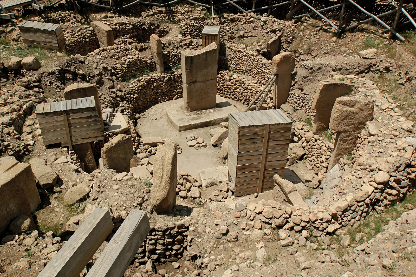
In Enclosure C at Göbekli Tepe, the curved stone wall wanders. It bulges and flattens the way a wall does when it is built by hand and patched over generations. Yet two archaeologists marked 32 points along its inner face, one every metre, and asked a computer for the one spot that sat most evenly among them. The answer did not fall somewhere vague on the floor. It fell on an exact mark: the midpoint between the front faces of the two great pillars that stand at the heart of the ring, facing south.[1]
From that mark the room repeats itself. Along the main axis, the distance out to the inner faces of the twin pillars is about 2.8 metres. The distance from those faces to the inner face of the ring wall is the same again.[1] The ring next door, Enclosure D, obeys the same rule. So does Enclosure F, west of the main excavation area. So, it seems, does a cult building raised later at Nevalı Çori, where the twin central pillars stand in a rectangular room but are placed by the same logic.[1]
That is a rule, and a rule has to be held by someone. The people who held it had not yet made pottery or invented writing, and no domesticated plant or animal has turned up in their layers.[1][3] In 2020 their rule made headlines in a narrower form, as a triangle. The rule behind the triangle, and the craft behind the rule, mostly did not. Follow that craft and it leads back to a semicircle laid out by villagers in what is now Israel, then forward to a hexagon on the Euphrates and a unit the length of a forearm built into the floors of Çayönü. It leads almost everywhere except to the place where someone first learned it.
A ring with a rule inside it
Göbekli Tepe is an artificial hill, 15 metres high and about 9 hectares across, roughly the area of a dozen football pitches, on a limestone ridge in Şanlıurfa Province in southeastern Türkiye.[1] Its oldest monuments are great stone rings. Each is a wall set with T-shaped limestone pillars 3 to 4 metres tall, closing around a pair of larger central pillars up to 5.5 metres high. In their final form the rings measure 10 to 30 metres across, and they may once have been roofed.[1] Clay mortar from the wall of Enclosure D has been radiocarbon dated to between about 9745 and 9314 BC.[1] No domesticated plants or animals have been found in those early layers, which is why the builders are taken to have been hunter-gatherers.[1]
Enclosure D is the grandest. Its inner floor runs to about 14 metres at the widest, its wall still stands more than 3 metres high, and 11 pillars have been exposed in it so far. Its central pair, 5.5 metres tall, stand on pedestals 20 to 30 centimetres high carved out of the bedrock itself. Of the three rings in this story, B, C and D, they are the only central pair carved with human arms and hands.[1]
The two archaeologists were Gil Haklay and Avi Gopher of Tel Aviv University, Haklay also with the Israel Antiquities Authority. They did no new digging. They took the excavators’ published plans and laid a grid of points over them, one every 5 centimetres. For each point a computer measured the distance to every pillar in the ring and kept the point where those distances varied least. The method has a dry name, standard deviation mapping, and a plain purpose: find the centre the builders were working from, if there was one.[1]
In C and D the centre landed on that same mark between the fronts of the central pillars. In Enclosure B, whose central pillars stand in a plaster floor rather than on bedrock pedestals, it landed near the middle of the space between them instead.[1]
The rule held in Enclosure F. It appears again at Nevalı Çori, a site of the following period, the Early Pre-Pottery Neolithic B, when farming was taking hold in the region. There it is the edge of the central pillars, not their middle, that lines up with the building’s main axis.[1][4] On Haklay and Gopher’s reading, a habit that survives the move from round rooms to rectangular ones is no builder’s quirk. It is a design rule, remembered and passed on.
Three rings, one design
Then Haklay and Gopher joined the dots. The centres of B, C and D sit within 25 to 28 centimetres of the corners of a perfect equilateral triangle with sides of about 19.25 metres, a distortion of under 1.5 per cent.[1] Over a distance of nearly 20 metres, the corners are out by roughly the length of a sheet of paper. A triangle like that needs no instruments. Stretch a cord of the right length to fix two corners, peg two more cords of the same length at those points, and swing them until they meet. Where they cross is the third corner.[1]
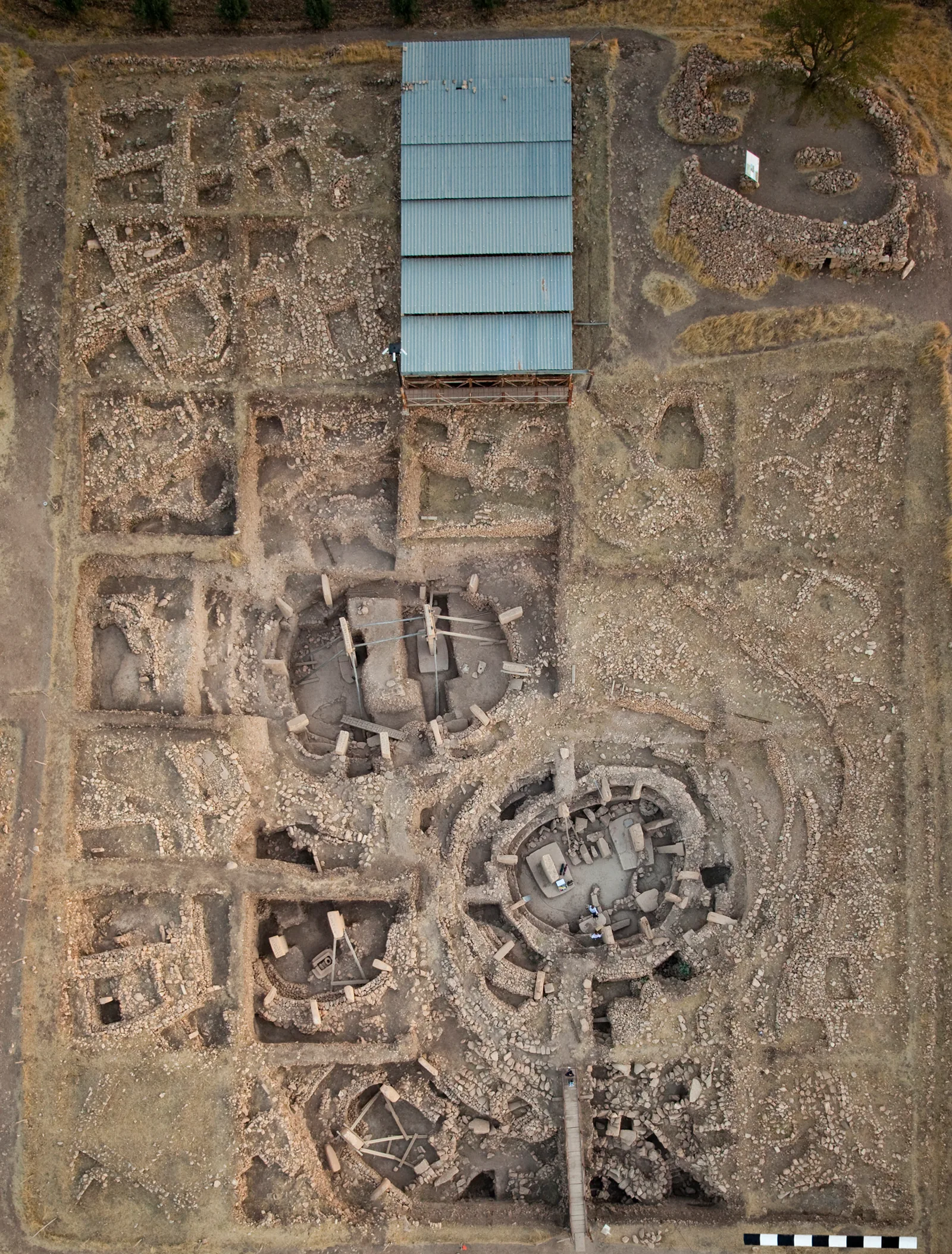
What the triangle organises is more interesting than the triangle. The central pillars of B and C line up along its southern side. A main axis drawn at a right angle to that side runs through the centre of D. Two U-shaped stone gateways, the eastern one about 3 metres by 3, sit symmetrically on either side of that axis, though the authors flag this last point as less certain.[1]
On their reading, D sits at the head of the whole complex. It is the largest ring, with the tallest pillars and the only armed central pair, and the excavator singled it out as the only ring showing all the main game animals.[1] A fox appears on every central pair, in B, C and D alike, as if marking one family of buildings.[1]
They do not claim the three rings were built at the same moment.[1] They claim something larger. If B, C and D were planned as one project, they write, the labour estimated for Göbekli Tepe “should be multiplied by three”.[1] That is a statement about organisation as much as geometry. Someone had to see the whole complex before its first pillar went up, and someone had to persuade others to build it.
Before the triangle, a circle
It would be easy to make this a story about a sudden genius. The record does not allow it.
Eynan, also called Ain Mallaha, was a village of the Natufian culture, in what is now Israel. It was occupied from about 15,000 to 12,000 years before present, which radiocarbon specialists count back from 1950, so roughly 13,000 to 10,000 BC.[2] There Haklay and Gopher re-examined a building known as Shelter 51. They found it had been laid out as a true semicircle, with its postholes set in exact concentric rings, and they suggest it was drawn with something like “a compass arm”, a cord or pole pinned at a centre and swung.[2] They called the result “a plan… [that] can be called Architectural with a capital A”.[2]
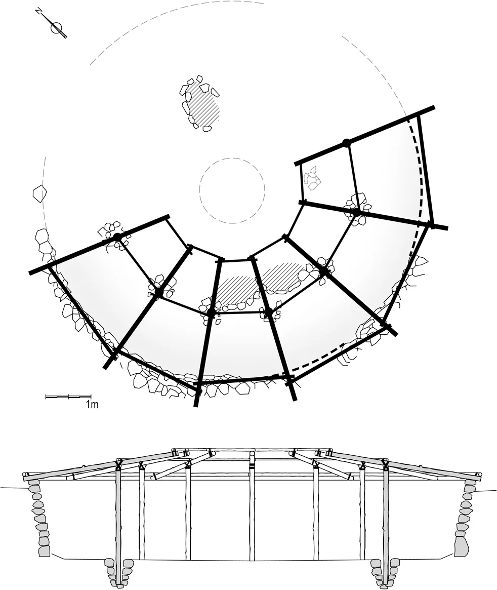
So the craft has a parent, and it is a real one. Natufian people knew how to fix a centre and turn a circle around it. What changes at Göbekli Tepe is scale and kind. Haklay and Gopher suggest that the simpler Natufian plans “may have been mental ‘cognitive plans’”, held in the head. The leap in complexity at Göbekli, in their view, “must have required” a small-scale schematic floor plan, a pattern built from geometry and regulated by a unit of length.[1]
A circle needs one centre. A complex of three rings set on a triangle, with an axis and paired gates, needs a plan of relationships between things that stand 20 metres apart. Nobody has yet found the steps between the first and the second.
A hexagon on the Euphrates
The same centuries produced the same kind of thinking elsewhere. Jerf el-Ahmar, on the Euphrates in Syria, was lived in about 11,600 to 10,600 years before present, roughly 9650 to 8650 BC, the same early period as Göbekli’s rings. The authors count its people among the region’s last hunter-gatherers; plants were domesticated there only a few generations after it was abandoned.[3] In one round building, EA53, the excavator Danielle Stordeur had noted that a bench formed a “perfect equilateral hexagon”. Haklay and Gopher ran their centre-finding method on it and confirmed it.[3] A regular hexagon is six equilateral triangles sharing a centre, and the authors set the two constructions side by side.[3]
A second building there, EA30, held something new. Measured out from a single centre, all nine corners of its central floor lie at whole-number multiples of one length, about 0.54 metres. Lines from that centre also mark out two rectangles of 3 units by 4.[3] That is counting applied to the ground. The authors are careful: the unit was “most probably not a standardised unit”, perhaps used only for this building.[3] They also present Jerf el-Ahmar’s rectangular buildings as the earliest rectangular architecture yet recorded “in the Levant and worldwide”.[3]
Planning in units raises a practical puzzle, because the authors doubt these people had words for abstract numbers. Their answer, offered as a suggestion, is reeds. Planners may have cut reeds to the same length and used them as tokens to set out a small-scale plan, so that each reed stood for a length to be measured on the ground.[3] Nothing about that requires writing. It does require a method, and a method has to be taught.
A forearm in the floor at Çayönü
At Çayönü, by a tributary of the upper Tigris in southeastern Türkiye, the craft hardens into a standard. Çayönü is one of the oldest sites with domesticated emmer wheat, part of the farming world that followed Göbekli’s first rings.[4]
Its later Terrazzo building has a floor in an exact ratio of 5 to 4, set out on a grid of about 0.48 metres. The same unit fits a house of the same date and an earlier building raised on parallel stone foundations, the type called a grill plan. Haklay and Gopher conclude that one unit “was used both in special and domestic buildings since the very onset of rectangular architecture at the site.”[4] Shrines and homes were measured with one rule.
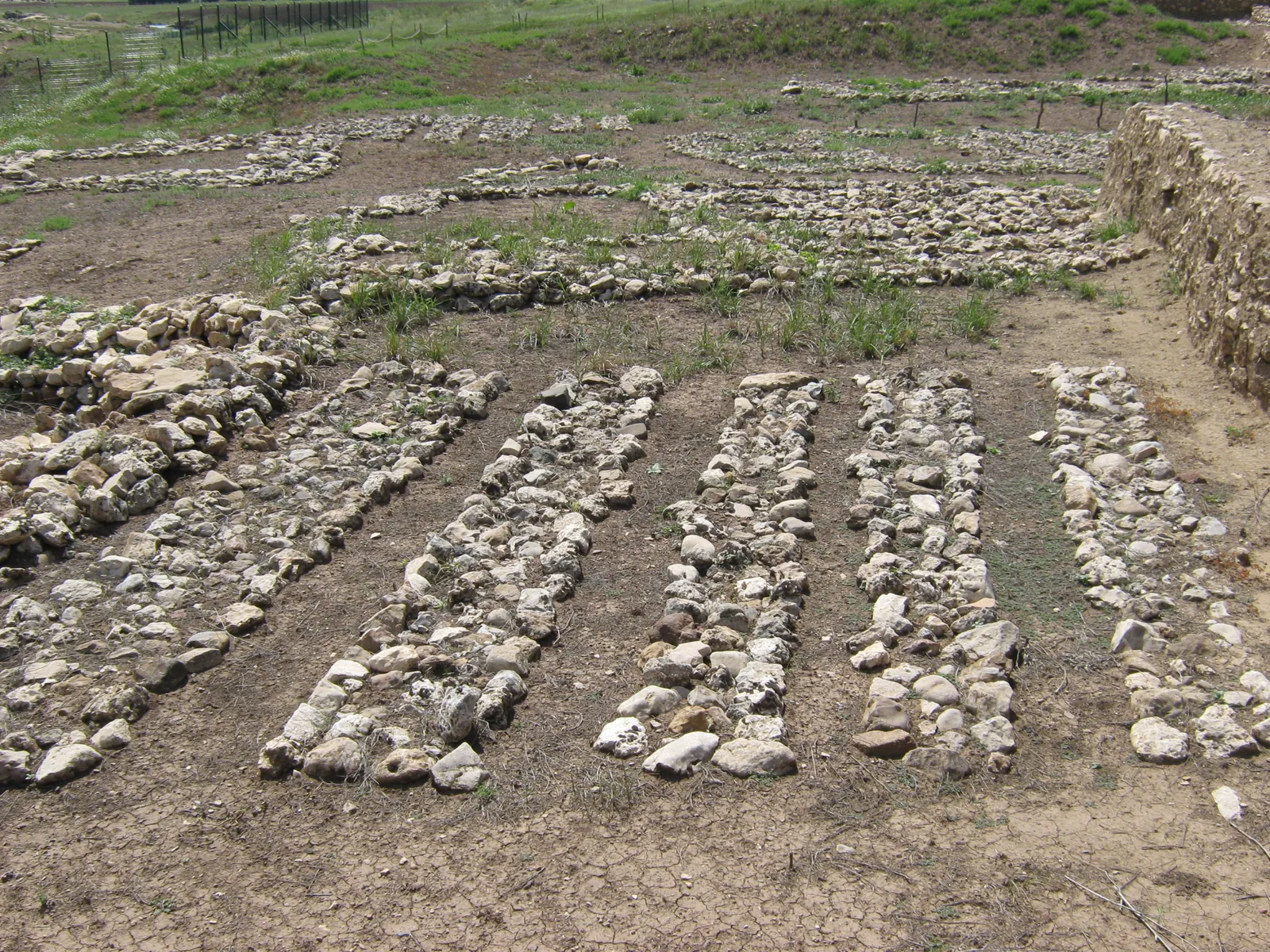
Here enthusiasm usually runs ahead of the evidence, so the anatomy comes first. A cubit is the length from the back of the elbow to the tip of the middle finger, and the old cubits Haklay and Gopher list, all based on it, fall between 0.444 and 0.524 metres.[4] Our reading follows: any forearm unit is likely to land in that band.[4] So when the authors say 0.48 metres “calls to mind” the Egyptian cubit of 0.450 metres, the royal cubit of 0.524, the Sumerian of 0.502 or the Roman of 0.444, the resemblance shows that people everywhere measured with their arms.[4] On its own it says nothing about knowledge travelling from Çayönü to the Nile.
What the authors find harder to explain is the speed. Çayönü’s own excavators, Özdoğan among them, described a long and gradual transition from round to rectangular buildings.[4] Haklay and Gopher read the same floors differently. To them the change looks “rather abrupt”, arriving with “an impressive arsenal of architectural planning tools” already in hand, through what they call “knowledge-based top-down processes”.[4] Two teams, one site, opposite readings. The disagreement is honest, and it is still open.
Testing for a unit
If Göbekli’s planners had a unit, the published lengths might show it. So we tried. The method is simple enough to check at home. Divide each published Göbekli length by the two units known from the period, 0.54 metres at Jerf el-Ahmar and 0.48 metres at Çayönü, and see how close the answer comes to a whole number.[11]
The best fit looks exciting for a moment: the triangle’s side of 19.25 metres divided by 0.48 gives 40.10, only 5 centimetres from exactly 40 units.[11] But a near miss means little on its own. For any length chosen at random, the answer lands within a tenth of a whole number about one time in five.[11] The same 0.48 metre unit fits Göbekli’s other figures poorly: the 2.8 metre spacing in Enclosure C comes to 5.83 units, and the 17 metres across the inside of Enclosure C’s second wall to 35.42. The Jerf el-Ahmar unit fits Enclosure D’s 14 metre floor neatly, at 25.93, then misses the triangle by 19 centimetres.[11]
The deeper problem is that the triangle’s own corners are out by 25 to 28 centimetres, roughly half of either unit.[11] A layout that loose cannot tell one unit from another, and the published figures are rounded besides. Haklay and Gopher themselves never name a unit for Göbekli Tepe; they say only that the plan was “regulated by a length module”.[1] Our test is inconclusive. Which unit, if any, the planners counted in remains unknown.
The people who held the cord
The most striking lines in these papers are not about geometry. They are about power.
Writing about Jerf el-Ahmar, Haklay and Gopher put it bluntly: “It was not common knowledge. Not everyone could plan a detailed design that can be accurately executed.”[3] In the same passage they say it is clear to them that at Göbekli Tepe “the planner (architect) was not the leader”.[3] Gopher told the Israeli newspaper Haaretz, as quoted by Smithsonian, that “this is a society that has an architect and somebody who initiates a project like this and has the power to make it happen”.[8]
In a world of foragers, the person who can call a crowd to a hill holds one kind of power. The person who knows where the third peg goes holds another, quieter kind. If the authors are right, those were already two different people. One reading, and it is ours rather than theirs: the leader could summon the labour, but the shape of the work depended on someone else. The papers do not say how that someone learned the craft. They say only that it was not everyone’s.
The authors’ larger claims come in the same spirit. They call the floor plan “probably the biggest step forward in Neolithic architectural planning.”[1] They describe Göbekli Tepe as “a quantic jump of the latest hunters-gatherers in the region”, a world “way beyond the capacity of a pristine hunter-gatherer society.”[1] Those are their words and their interpretation, and they are not settled.
A careful reader will want one more fact. Four of the core papers behind this picture, on Eynan in 2015, Çayönü in 2019, and Göbekli Tepe and Jerf el-Ahmar in 2020, share the same two authors.[1][2][3][4] The craft described here is, so far, largely the reconstruction of one research programme. That does not make it wrong. It means few other hands have checked it.
The case against the triangle
The objections are good ones, and deserve full weight.
The first is about geometry itself. Martin Sweatman, an engineer at the University of Edinburgh, points out that three similar rings built nearly touching will put their centres close to an equilateral triangle almost automatically. Three coins pushed together on a table do the same. He notes that no statistical test was run, and he concludes, “probably their result is pure chance.”[9] He adds, in a reading we have not checked, that radar of the unexcavated mound shows no repeat of the pattern and that Enclosure A does not fit.[9] The skeptic Jason Colavito makes the same packing point and asks a sharper question: why would builders make “an equilateral triangle accurate to a few centimeters but not bother to make the enclosures truly circular”?[10]
The second objection is about time. The excavation team, writing for the German Archaeological Institute in 2020, sees the rings as buildings with many phases. Lee Clare reports that in some cases their final building phases date to “in excess of five centuries after their initial foundation”. The old three-layer sequence for the site has been abandoned, and much of the fill inside the rings now looks like debris that slid down from higher ground, not a deliberate burial.[5]
That matters, because Haklay and Gopher measured the final positions of the outer pillars. Their answer is that the central pillars of C and D sit on pedestals cut into bedrock, which most probably belong to the first build, and that every later change kept to the same centre.[1] It is a reasonable answer, and an inference about five centuries of rebuilding that the triangle alone cannot prove.
Outside scholars added doubts of their own, as Smithsonian reported. Tristan Carter of McMaster University suggested one ring could have come first, with the others placed around it later. Anna Belfer-Cohen of the Hebrew University noted that the rings might still have been built “perhaps by different groups”.[8] In 2025 Gopher and Haklay pressed their method further, suggesting that where geometric analysis and the excavated layers disagree, “the architectural analysis” may be the one to trust.[7] It is a bold position for a team that did not dig the site.
Then there are the plain limits. The authors judged the triangle “less likely to be coincidental, nor the result of a self-organization process”, but they offered no statistical test.[1] We looked for one by anyone else, and for any replication or formal rebuttal, among the 24 works that OpenAlex, an open index of research papers, lists as citing the paper. By November 2026 none had appeared that we could find.[12]
And most of the site is still buried. Four of the early rings have been uncovered in the main excavation area, and a geomagnetic survey points to at least 15 more still in the mound.[1] The triangle is a pattern found in a small sample.
Here is where the mainstream case is strong and where it stops. Packing can explain three centres sitting close to a triangle. It does not obviously explain why the central pillars of B and C line up along one side of it, or why the centre of a wandering ring lands exactly between the fronts of its central pillars. Nor does it explain why that rule shows up again in a rectangular room at Nevalı Çori, or a hexagon at Jerf el-Ahmar, or a 5-by-4 floor on a grid at Çayönü. Those are also Haklay and Gopher’s own analyses, so they stand or fall together. But they are not the same kind of coincidence.
A plan older than any surviving scale drawing
The dates are where the story turns uneasy. If Haklay and Gopher are right that Göbekli’s design needed a small-scale plan, that plan existed when Enclosure D’s mortar was laid, between about 9745 and 9314 BC.[1]
The oldest realistic plans drawn to scale that anyone can actually hold are engraved stones from Jordan and Saudi Arabia. They show desert kites, huge stone-walled traps for hunting game, and the team that published them calls their precision remarkable. Rougher sketches of built spaces are known from the Stone Age, but that team describes them as schematic and not accurate. The site where the Jordanian stone was found dates to about 6930 BC.[6]
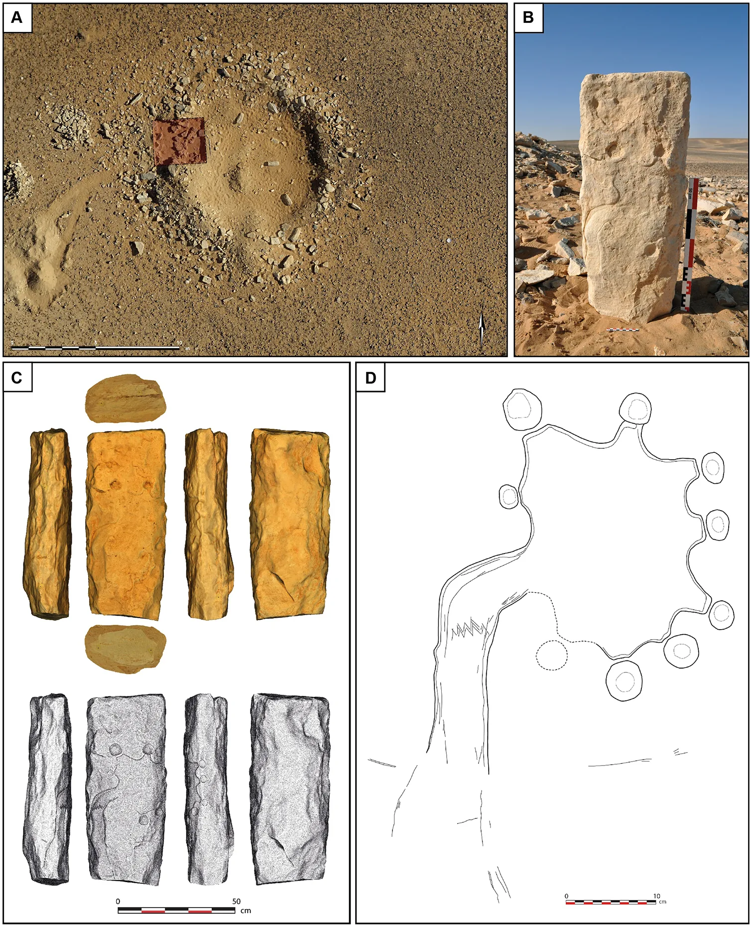
The inferred plan at Göbekli Tepe would be older than that by roughly 2,400 to 2,800 years, our subtraction from the two published dates.[1][6] When the triangle was announced, the press statement, as Smithsonian summarised it, said scholars had thought geometric floor plans began with farming, some 10,500 years ago.[8]
So the planning came first, and if it was ever set down, no copy has been found. It may have been scratched in dirt, laid out in reeds, or held on something that rotted long ago.
Where the cord was first stretched
Within a few thousand years of Eynan’s circle, foragers were relating whole buildings to one another with a constructed triangle, and their contemporaries on the Euphrates were counting units across a floor. The evidence suggests a craft, specialist and teachable. If Haklay and Gopher read Çayönü rightly, it arrived faster than the gradual account can yet show. None of this proves it, and the people who reconstructed it are, for now, almost alone in having looked.
The question it raises is not whether foragers could stretch a cord. They plainly could. It is where the knowledge of which cord, which centre and which proportion came from, who held it, and who taught it to them. Most of Göbekli Tepe’s rings have never been dug. Somewhere between Eynan’s semicircle and the limestone ridge above Şanlıurfa, someone first showed someone else how to swing two cords from two pegs until they cross, and why that point mattered. No excavation has yet found that place, or that person.
Sources
- Haklay, G. & Gopher, A. 2020. Geometry and Architectural Planning at Göbekli Tepe, Turkey. Cambridge Archaeological Journal 30(2): 343–357. https://doi.org/10.1017/S0959774319000660 (open access)
- Haklay, G. & Gopher, A. 2015. A New Look at Shelter 131/51 in the Natufian Site of Eynan (Ain-Mallaha), Israel. PLoS ONE 10(7): e0130121. https://doi.org/10.1371/journal.pone.0130121
- Haklay, G. & Gopher, A. 2020. Geometry, a measurement unit and rectangular architecture at Early Neolithic Jerf el-Ahmar, Syria. Paléorient 46(1–2): 31–42. https://doi.org/10.4000/paleorient.297
- Haklay, G. & Gopher, A. 2019. Architectural planning and measuring in the Pre-Pottery Neolithic site of Çayönü, Turkey. Paléorient 45(1): 7–17. https://doi.org/10.4000/paleorient.508
- Clare, L. 2020. Göbekli Tepe, Turkey: a brief summary of research at a new World Heritage Site (2015–2019). e-Forschungsberichte des DAI 2020/2. https://www.bicga.org.uk/docs/Gobekli_Tepe_Turkey_A_brief_summary_of_r.pdf
- Crassard, R. et al. 2023. The oldest plans to scale of humanmade mega-structures. PLoS ONE 18(5): e0277927. https://doi.org/10.1371/journal.pone.0277927
- Gopher, A. & Haklay, G. 2025. Mobilizing architectural formal analysis for stratigraphic decision-making. Archaeological Research in Asia 41: 100581 (abstract only). https://cris.tau.ac.il/en/publications/mobilizing-architectural-formal-analysis-for-stratigraphic-decisi/
- Fox, A. 2020. Did Geometry Guide the Construction of the World's Oldest Temple? Smithsonian Magazine, 28 May. https://www.smithsonianmag.com/smart-news/ancient-geometry-discovered-worlds-oldest-temple-180974991/
- Sweatman, M. 2020. An equilateral triangle at Gobekli Tepe? Prehistory Decoded (blog), 30 April. https://martinsweatman.blogspot.com/2020/04/an-equilateral-triangle-at-gobekli-tepe.html
- Colavito, J. 2020. Israeli Researchers Claim Hidden Geometry and Secret Symbolism at Göbekli Tepe (blog), 29 April. https://www.jasoncolavito.com/blog/israeli-researchers-claim-hidden-geometry-and-secret-symbolism-at-gobekli-tepe
- Our unit check: method and full table in
research/unit-check-calc.md(inputs from [1], [3], [4]). Inconclusive by design. - OpenAlex, works citing Haklay & Gopher 2020 (24 as of 10 Nov 2026). https://api.openalex.org/works?filter=cites:W3000070339
Images are real photographs and published journal figures, credited and licensed in each caption; none is AI-generated, and no labels or overlays were added. Speculation is labelled as such in the text. Unit-check notes ([11]) are held in the article’s research file.