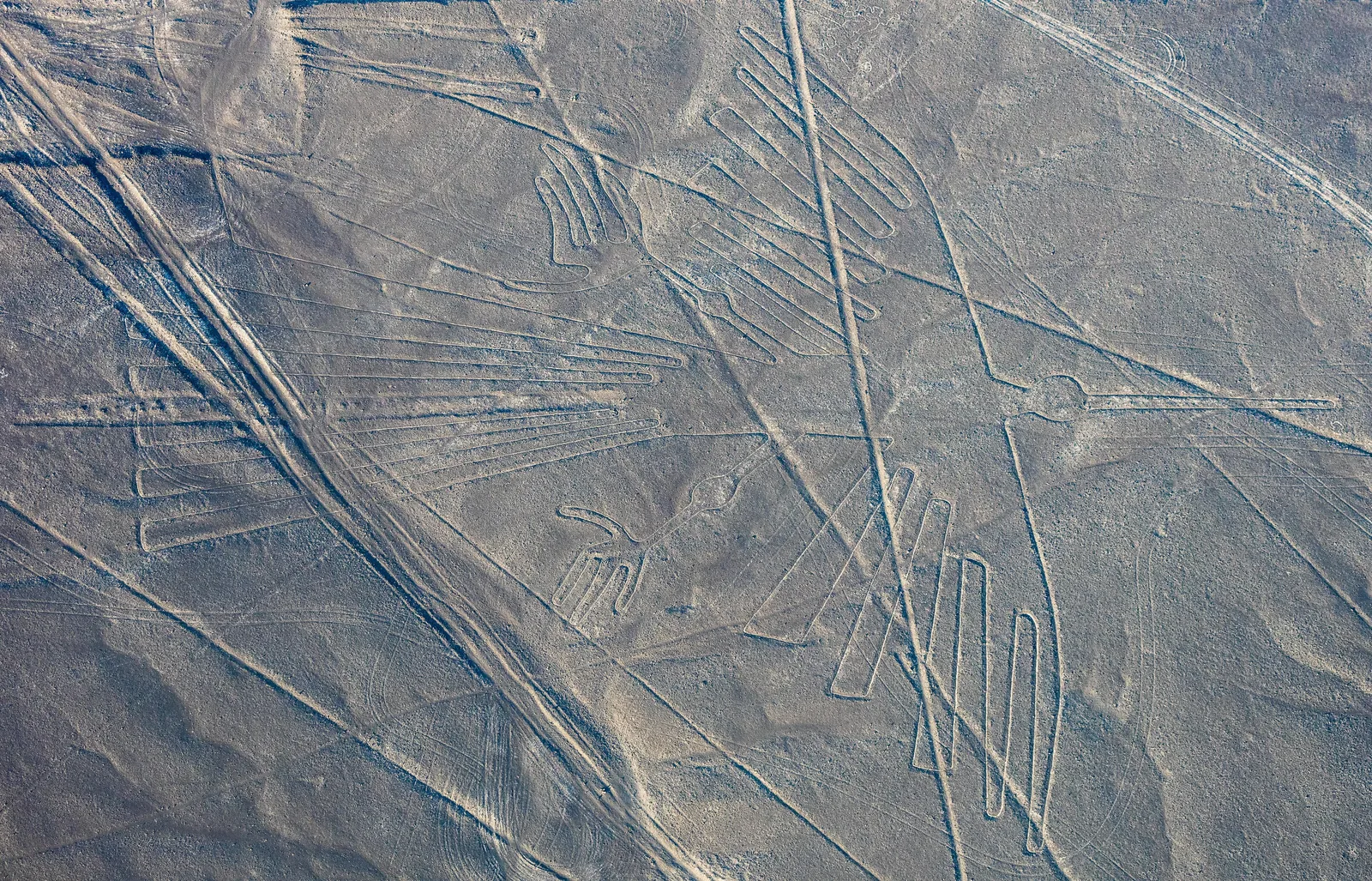
The Nazca drawings could be laid out from the ground, as a 1982 full-size replica of the condor showed, and the oldest figures in the region, faces on the Palpa hillsides, were made to be seen from the valleys. Later the drawings moved onto flat ground and mostly became places to walk and gather. The giant animals are the exception: by the archaeologists’ own test they are true pictures, yet by the viewing angle one of those archaeologists used, a standing person could take in only a few metres of them at once. The average giant needs an eye about 26 metres up. This piece sets out the evidence, the mainstream answers, and the question none of the sources settles: who those pictures were for.
Contents 8 sections · 16 min
The average giant animal drawn on the Nazca pampa is about 90 metres long [1]. When the archaeologist Karsten Lambers tested how such figures could be seen from the ground, he assumed that a figure lying flat is recognisable only when the eye looks down on it at 30 degrees or more [2]. Put those two numbers together, and the eye that takes in an average giant whole has to hang about 26 metres above its middle. That is roughly the height of an eight-storey building.
The figures lie on a flat desert tableland about 500 metres above the sea [1]. No source we opened describes anything the makers built that would have lifted a person that high.
This is not the old claim that the drawings could only have been made from the air. They could be laid out from the ground, as a family in Kentucky showed with stakes and rope in 1982 [4]. Nor does every figure in this desert need altitude. The oldest ones were made to be seen by people standing in the valleys, and archaeologists can show it [2].
The puzzle is narrower and harder. Over a few centuries, the people of this coast moved their pictures from the hillsides, where human eyes could read them, onto flat ground. Most of what they drew there was never meant to be a picture at all.
But for a while they also drew enormous, faithful images of animals, on ground where nobody standing could ever see them complete. Then, as far as the record shows, they stopped [2].
A Picture Made by Lifting Stones
The pampa lies some 400 kilometres south of Lima, in one of the driest places on Earth [5]. UNESCO’s description of the site records the lowest rainfall rates in the world, with water arriving only in El Niño years [5]. On the high plains between the river valleys, the wind has blown the sand from between the stones. What remains is a thin, tight skin of dark, oxidised stones known as desert pavement [2].
To draw on it, you pick up the dark stones and move them. Underneath lies a pale, sandy layer. Pile the lifted stones along the edge of the cleared strip and the contrast sharpens, dark against light [2][1].
Lambers, whose doctoral thesis documents the geoglyphs around the town of Palpa, calls this “technically a relatively simple task requiring mainly a certain amount of labor investment” [2]. Once people stopped walking on a cleared surface, a thin crust formed over it and held it against the wind. The drawings survived because they were abandoned [2].
UNESCO places the drawings in two broad phases: a Paracas phase from about 400 to 200 BC, and a Nasca phase from about 200 BC to AD 500 [5]. The 2024 survey team stretches the Nasca period to about AD 650 [1]. Most of what the desert holds is not pictures. It is straight lines running for kilometres, cleared trapezoids hundreds of metres long, spirals and zigzags, and figures of animals and people make up by far the smallest share [5][2][1].
The figures come in two styles [1]. The small “relief-type” figures, about 9 metres across on average, were made by clearing patches of ground and heaping the stones. Most of them show people, severed heads and llamas [1][2].
The “line-type” figures are the famous ones: the monkey, the whale, the condor. They are outlines drawn as cleared lines, they average about 90 metres, and most of them show wild animals [1][4].
Our record pages on the Nazca geoglyphs and the Nazca lines tell the story of the 2024 survey that used AI to find hundreds of the small ones. This piece asks a different question. Who, in their own time, could see these pictures?
Six People and a Rope
The first thing most people ask is how anyone could draw a bird 134 metres long without seeing it from above. That question has a good answer, and it was given on a landfill in Kentucky.
On 7 August 1982 the investigator Joe Nickell set out to copy the Nazca condor at full size on a landfill at West Liberty [4]. His crew was his father, three cousins and his 11-year-old nephew [4]. Their method was the simplest they could think of. They ran a centre line down a small drawing of the condor and measured, for each point on the outline, how far along the line it sat and how far out to the side [4].
Then they did the same on the ground with bigger units. They borrowed a unit that Maria Reiche, the German mathematician who spent her life measuring the Nazca drawings, had derived from her surveys: about 32 centimetres [4]. They painted it onto ropes, tied a knot every ten units, and kept their sideways measurements square with a T made of two strips of wood [4].
After about nine hours they had staked 165 points and joined them with twine. The outline came to just over a mile of string [4]. Rain held them up for a week. When the ground dried they marked the lines with white lime, since they could not lift stones the way the Nasca did [4].
Then they went up in a Cessna and photographed the result from just under 1,000 feet [4]. The bird was there. The results were so accurate, Nickell wrote, that “we could have easily produced a more symmetrical figure” [4].
That last remark carries a clue. The real condor is not symmetrical. Its wings are askew and its feet do not match, which led Nickell to think the Nasca plotted fewer points than he did and drew some parts freehand [4].
Reiche, as Nickell reports her work, described small plots about six feet square near many of the large figures, where she believed the designs were first sketched [4]. She also reported stones or holes at the points that served as centres for the curves [4]. The method works. Ground methods explain the making.
Reiche herself was less sure. She once wrote, Nickell notes, that “Ancient Peruvians must have had instruments and equipment which we ignore” [4]. On the evidence of Nickell’s landfill, they needed nothing of the kind.
But the replica answered only the question of how. It said nothing about who the bird was for.
The Faces on the Hillsides
To see what the first drawings were for, you have to leave the famous pampa and go north to Palpa. There the Nasca-Palpa Archaeological Project recorded more than 1,500 geoglyphs [3]. Lambers used that record to work out which shapes came first.
The answer was faces. The earliest geoglyphs in the Palpa sample are human-like figures, and every one of them sits on a hillside [2]. They face the viewer square on. Heads and bodies are cleared patches of ground, eyes and mouths are small heaps of stones, and some wear headdresses of radiating lines [2].
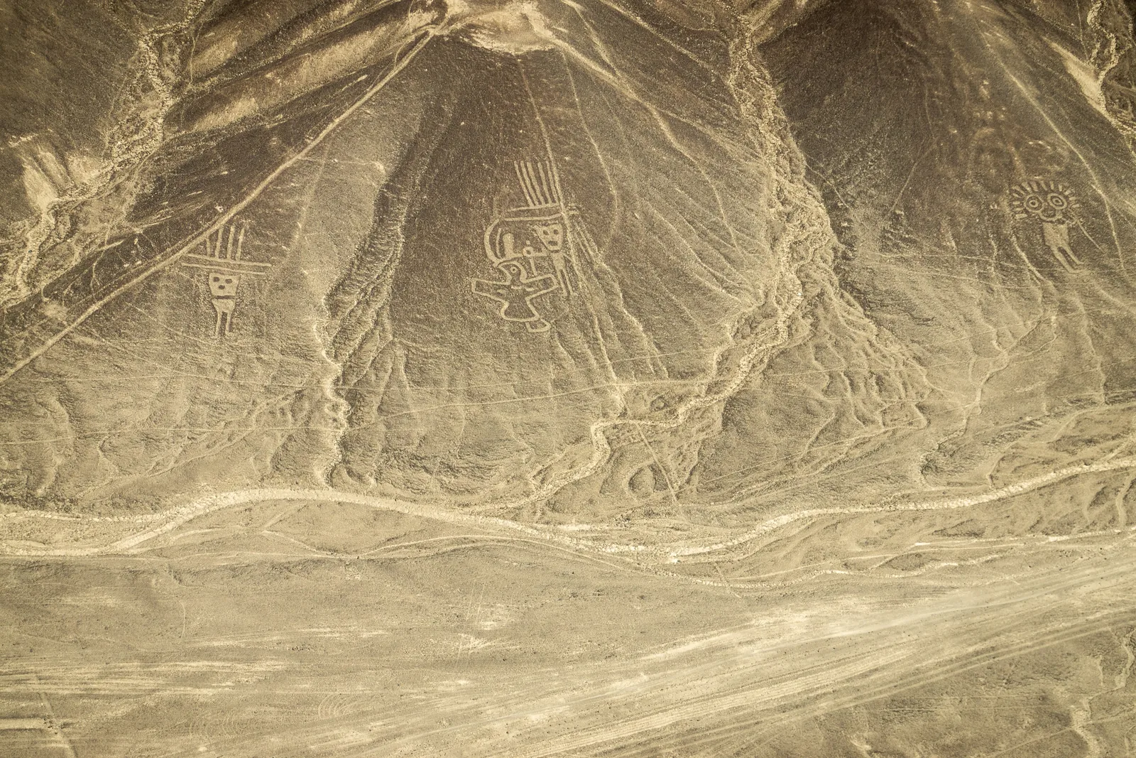
Some hold long objects that may be serpents or staffs; others carry trophy heads [2]. They closely resemble figures embroidered on textiles from the Paracas Necrópolis burials, which is how Lambers dates them to the late Paracas period. His conservative date for the first of them is about 400 BC, and he writes that a much earlier date cannot be ruled out [2].
They did not appear from nowhere. People had carved images into boulders on the same hillsides, more than 200 of them at Chichictara, 11 kilometres up the valley from Palpa, most likely in Paracas times [2]. Lambers thinks the ground drawings began as a transfer of those carved images from the boulder to the slope around it [2].
Everything about the hillside figures says they were made to be looked at. They are hard to walk on and carry few pots or offerings. There is no sign that any was left half-finished, and they were placed so they could be seen whole from certain points in the valley [2]. “Their primary function was apparently to be seen, to convey a message to their observers,” Lambers concludes [2].
The 2024 survey on the Nazca pampa found a matching pattern in the small relief figures there. Earlier studies had noticed that they tend to lie on hill slopes “so that it can be seen from a distance” [1]. The survey team found them on average 43 metres from ancient footpaths, and every one that stands alone is visible from those paths [1]. Visible is not the same as legible, though. By our arithmetic, a flat figure 43 metres away lies under 3 degrees below a standing eye, squashed to about a twenty-fourth of its depth, which may be one reason so many sit on slopes.
A slope does something simple for a picture. It tilts the picture up toward the person looking at it. The first image-makers of this coast built their drawings for human eyes, at the angle human eyes need.
From Pictures to Stages
Then the drawings moved. In the Palpa record, the first geoglyphs on the flat plateaus appear in the Initial Nasca period, around the turn of the era, and the tradition peaks in Early Nasca times [2][1].
On the flat, the drawings changed their job. People walked on them. Lambers found the cleared lines and parts of the trapezoids packed down by feet, with stone platforms built on them [2]. Offerings were left along their edges and on the platforms, most prominently Spondylus shells, which Lambers and Sauerbier tie to Andean ideas of water and fertility [3].
The shapes were cleared, widened, redrawn and remodelled over centuries [2]. Tall wooden posts on some trapezoids may have marked their position for people down in the valley [2].
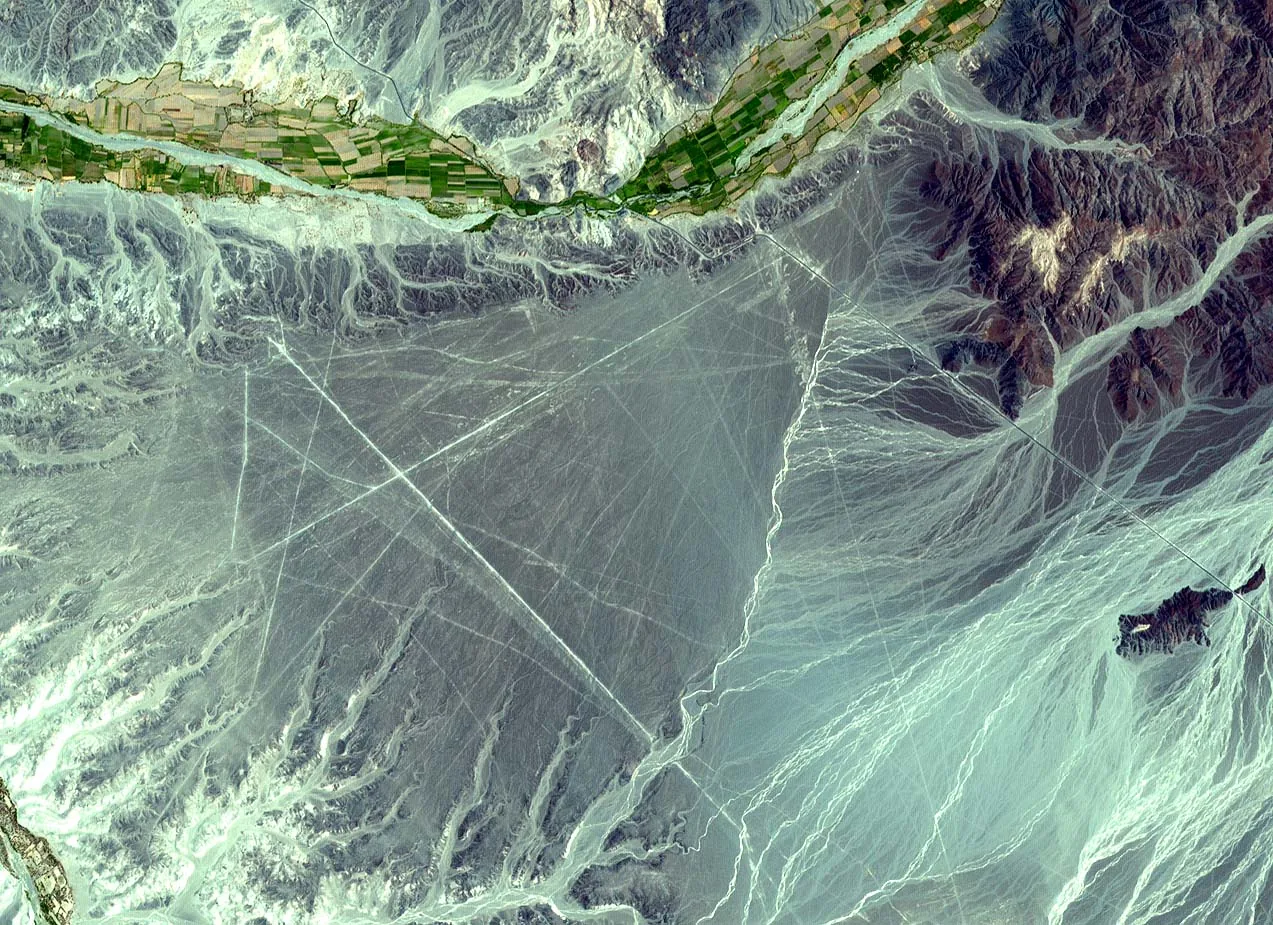
Lambers and the photogrammetrist Martin Sauerbier then ran a computer test of what could be seen from where. They compared points on geoglyphs with random points in the same terrain, and the geoglyph points were consistently more visible, by a statistically clear margin [3]. Aerial photographs, they wrote, had created “the false impression that they are only visible from above” [3].
Groups of people gathered on a trapezoid would have been silhouetted against the desert from far away, even where the trapezoid itself could not be made out [3]. Lambers puts it bluntly: “people on geoglyphs, rather than geoglyphs themselves, may well have been the main focus of common perception” [2]. In this reading the later geoglyphs were not pictures at all. They were stages.
The 2024 survey on the Nazca pampa fits the same frame. The giant line-type figures sit on average 34 metres from the great straight lines and trapezoids, and the team judged it highly likely that people reached them on foot from that network [1].
The team reads the network as a pilgrimage route from the Ingenio valley to the temple of Cahuachi and a sacred meeting of two rivers [1]. Roughly ten trapezoids, between 300 and 950 metres long, served as ritual squares, with 24 line-type figures gathered around them [1]. In the team’s view it is “highly probable” that rituals were performed on the giant figures at the start or end of the journey [1].
The art historian Alan Sawyer, quoted by Nickell, noticed decades ago that most of the figures are drawn with a single line that never crosses itself, “perhaps the path of a ritual maze” [4]. Nickell agreed, allowing for exceptions [4]. In 1984 the archaeoastronomer Clive Ruggles stumbled across a 4.4-kilometre labyrinth on the pampa whose form he could make out only by walking it end to end [6]. He dates it to around AD 500 and thinks it was meant to be experienced from inside, not seen from outside [6].
This is a strong account, built on decades of ground survey, and it explains most of what lies on the desert. But it rests mainly on lines, trapezoids and labyrinths, and Ruggles himself marks its edge. His labyrinth, he writes, has an irregular form that “provides no reason to speculate that it might have been intended to be viewed from the air,” unlike “some of the famous zoomorphic figures” [6].
The Eye-Height Problem
So how much of a giant figure could a person standing beside it actually see?
Lambers gives us the tools. When he tested how far away the Palpa figures could be recognised, he set the eye of his imagined observer 1.80 metres above the ground [2]. He assumed that a figure lying flat could be recognised only where the observer looked down at it at 30 degrees or more [2]. At that angle a flat shape looks squashed to about half its true depth.
He set that angle for the hillside human figure he was testing, and he notes that any flat figure needs some such minimum [2]. Those are an archaeologist’s working assumptions, not ours. Apply them to the average sizes measured in the 2024 survey and to Nickell’s condor, and the arithmetic takes a minute. The method sits under the table so anyone can check it.
A person standing on flat ground sees the ground at 30 degrees or more only within about 3 metres of their feet. That makes a circle about 6 metres across, roughly the width of a two-lane road. An average relief-type figure, at 9 metres, is not much bigger than that circle. An average line-type figure is more than fourteen times wider.
| Figure | Length | Eye height needed, directly over the middle | Eye height needed, from one end |
|---|---|---|---|
| Average relief-type figure | 9 m | about 2.6 m | about 5.2 m |
| Average line-type figure | 90 m | about 26 m | about 52 m |
| The condor (Nickell’s size) | 134 m | about 39 m | about 77 m |
Our calculation, from Lambers’s 30° threshold and 1.80 m eye height [2], the 2024 survey’s average sizes [1] and Nickell’s condor [4]. Method: an eye at height H sees flat ground at 30° or steeper only within H ÷ tan 30°, about 1.73 × H, of the spot beneath it. To take in a figure of length L from over its middle, H must be at least 0.29 × L; from one end, at least 0.58 × L. Assumes flat ground and a figure that fits inside a circle as wide as its length.
Two honest limits apply. Thirty degrees is a working figure, not a law of vision; drop it to 20 degrees and the average giant still needs an eye about 16 metres up. And the pampa is not a billiard table: erosion channels from the Andes foothills cross the plain [2]. We found no published terrain study of sight lines on the Nazca pampa itself like the one Lambers and Sauerbier ran at Palpa.
Lambers’s own field verdict is that on the Nazca pampa “some efforts are required to overlook a geoglyph from a ground perspective” [2].
The ground view is not blind, either. Standing beside his own condor, Nickell could make out whole parts of it: the head and body, a leg and foot, the fan of the tail [4]. His father brought a wildlife biologist to the site without telling him what it was. The man recognised it as one of the Nazca birds, then later picked it out from photographs as the condor [4].
Nickell concedes the test was weakened, because the biologist already knew the Nazca drawings [4]. Still, the point stands. A walker could know it was a bird. What a walker could not do was see the picture.
The Exception in the Model
Here is where the best mainstream account starts to strain.
Lambers drew a clear line between two kinds of geoglyph. The ones meant mainly to be seen were visible from a distance, repeated “motifs known from other media” such as textiles and pottery, and stayed unchanged once drawn [2]. The stages were not visible in their entirety, had shapes found on no other medium, and were constantly reworked [2]. It is a good test, and for the lines and trapezoids it works well.
The giant animals fail it from both sides. Their motifs are exactly the kind repeated on other media. Lambers notes that the biomorphic figures are the geoglyphs with counterparts on textiles and ceramics [2]. The 2024 team dates the line-type figures to the Nasca period in part because they resemble designs on Nasca pottery [1].
By Lambers’s own measure, then, they are pictures. And yet, by the same 30-degree rule, nobody standing on the flat pampa could see them whole.
They also belong to a moment. Pottery from Early Nasca, roughly AD 50 to 300, lies on the whale and the monkey [1]. In the Palpa record, animal and human figures are at their most common in Early Nasca. By Middle Nasca, Lambers writes, “apparently no more biomorphic figures and spirals were created” [2].
The tradition ran on for centuries afterward, reduced in the end to straight lines and large cleared areas [2]. If the same holds on the Nazca pampa, which only direct dating can show, the giant animals belong to a window of perhaps two or three centuries.
The mainstream has answers, and they deserve a full hearing. Nickell offered one for the practical side as early as 1983. Once a way of enlarging drawings had been proven on slopes, where results could be checked from below, it could be trusted on flat ground too [4]. The chronology worked out since then runs in that order, from hillside figures to plateau figures [2][1].
The pilgrimage reading answers the question of purpose. The giant figures were walked, as single lines, by people doing something sacred with their feet [1][4].
But a path does not need to be a likeness. A walker following a line gains nothing if the line, seen from above, is an accurate condor rather than a scribble. Ruggles’s labyrinth shows the Nasca knew how to make a sacred walk without a picture.
Yet someone, if Reiche read her planning plots correctly, sketched a condor small, enlarged it point by point, and laid it across the pampa [4]. UNESCO’s assessment of the site praises the technology that let its makers design large figures with “outstanding geometric precision” [5]. Nickell’s ropes suggest the condor is less exact than it could have been. Both can be true: exact enough to read, loose enough to show that nobody checked it from above.
Here is a guess, and it is only a guess. The condor’s askew wings and mismatched feet, the flaws Nickell’s ropes could have avoided, look like the work of people who never saw the finished bird. They had the plan and they trusted the method. The result was for someone else.
The 2024 team ends its discussion on a sentence that leaves exactly this door open: “This does not preclude the possibility that the Nazca geoglyphs may also have functioned at another level” [1]. Even Nickell, writing to bury the spaceship theories, granted that the figures’ “large size does suggest the possibility that they were meant to be viewed from above, as by the Indian gods” [4].
What Survives, and What Does Not
Some famous claims about Nazca do not survive contact with the record.
The idea that the long lines were landing strips began as a joke. Paul Kosok, the first scholar to study the markings, recalled in 1947 that when first seen from the air they were “nicknamed prehistoric landing fields and jokingly compared with the so-called canals on Mars” [4].
The idea that the Nasca flew over their own drawings got one famous test. Jim Woodman and the balloonist Julian Nott built a balloon of cloth, rope and reeds and flew it some 300 feet over the pampa [4]. It came down so fast that they jumped clear about ten feet above the ground, and the empty balloon shot back into the sky [4]. No source we opened offers any evidence that the Nasca flew, and nothing about making the figures requires it.
The dates are less settled than they look. In the 1980s and 1990s, researchers dated organic traces trapped under the natural varnish on stones moved during construction [2]. The results were later questioned over possible contamination, and the method was dropped [2].
Nickell reported a wooden stake at the end of one line dated to AD 525, give or take 80 years [4]. Lambers, reviewing earlier reports of dated posts, found that their exact context “was never clearly stated” [2]. At Palpa, one wooden post on a trapezoid gave AD 603 to 644 [2]. A newer method, which measures when buried stones last saw daylight, was still being tested when Lambers wrote [2].
What does survive is the question of the viewer. Here the record goes quiet, and anything said next is interpretation. One reading, close to Nickell’s own aside about the gods, is that the giant animals were addressed to powers in the sky or on the mountains. To such beings, a condor drawn on the pampa was a message they could read and the pilgrims could not.
Another reading, which the record neither supports nor rules out, is that the people of the pampa believed something above them was watching closely enough to be shown pictures, and for a time made pictures for it. Neither reading is established. Both take seriously what the walking explanation leaves over: the care spent on a likeness that no walker could see.
What would decide it? Direct dates for the giant animals themselves would show whether they really belong to one short window. A terrain study of the Nazca pampa like the one run at Palpa would show whether any natural viewpoint lets a person see them whole. And excavation of the small planning plots Reiche described could tell us who drew the original sketches, and when.
The Picture and the Path
The people of this coast began by drawing faces on hillsides, faces that looked straight out at the valley and were meant to be seen. They ended with straight lines and broad cleared floors where crowds could walk, gather and be watched.
In between, for perhaps two or three centuries, they drew condors, monkeys and whales at a size their own eyes could not hold. They very likely worked from plans small enough to sketch in a corner of the desert, and they walked the results, it seems, one line at a time.
Whoever laid out the condor worked from its shape, and nobody can show that any of them ever saw it whole. In 1982 a family in Kentucky needed a Cessna to check their copy. The people who drew the original had only the plan in their heads and a method they trusted. For all anyone can yet show, nobody saw their bird whole until people flew over the desert in the twentieth century [4].
Sources
- Sakai, M., Sakurai, A., Lu, S., Olano, J., Albrecht, C. M., Hamann, H. F. and Freitag, M. (2024). "AI-accelerated Nazca survey nearly doubles the number of known figurative geoglyphs and sheds light on their purpose." Proceedings of the National Academy of Sciences 121(40): e2407652121. https://doi.org/10.1073/pnas.2407652121 (open-access full text: https://europepmc.org/article/PMC/PMC11459208)
- Lambers, K. (2004). The Geoglyphs of Palpa (Peru): Documentation, Analysis, and Interpretation. PhD thesis, University of Zurich. https://www.archaeologie.uzh.ch/static/pdf/Lambers_Diss_2005.pdf
- Lambers, K. and Sauerbier, M. (2006). "A Fresh View on the Nasca Lines: Investigating Geoglyph Visibility in Palpa (Ica, Peru)." Computer Applications and Quantitative Methods in Archaeology (CAA 2006). https://proceedings.caaconference.org/files/2006/CD24_Sauerbier_Lambers_CAA2006.pdf
- Nickell, J. (1983). "The Nazca Drawings Revisited: Creation of a Full-Sized Duplicate." Skeptical Inquirer 7(3). https://skepticalinquirer.org/1983/04/the-nazca-drawings-revisited-creation-of-full-sized-duplicate/ (full text read from the archived CSI copy: https://web.archive.org/web/20160613013809/http://www.csicop.org/si/show/nazca_drawings_revisited)
- UNESCO World Heritage Centre. "Lines and Geoglyphs of Nasca and Palpa" (list no. 700). https://whc.unesco.org/en/list/700/
- Ruggles, C. "Desert labyrinth" (research summary of Ruggles and Saunders 2012, Antiquity 86). https://web.cliveruggles.com/research/desert-labyrinth
Cross-checked but not cited for unique facts: Yamagata University press release, 24 September 2024, https://www.yamagata-u.ac.jp/en/information/info/20240924/
Images are a photograph by Diego Delso (CC BY-SA 4.0), a photograph by PsamatheM (CC BY-SA 4.0), and an ASTER image from NASA/METI/AIST/Japan Space Systems and the U.S./Japan ASTER Science Team (public domain), credited and licensed in each caption; none is AI-generated, and no labels or overlays were added. Calculations in the table are labelled as ours. Speculation in the closing section is labelled as such in the text.
 William S. · InvestigationsWhere the evidence leads, we follow.
 Peru · ParacasWhat the Paracas Skulls RememberIn 1586 the Collaguas said they bound babies’ heads to match the volcano they came from. What the Paracas skull DNA file shows, and how old the custom is.15 min read
 Andes · SacsayhuamánThe Joint Nobody Could Measure at SacsayhuamánSacsayhuamán’s giant blocks are limestone, not the andesite of the famous tests, and no one has yet shown how joints this tight were cut at full scale.13 min read
 Ireland · OrkneyThe Note in the StoneNewgrange rings like a wind instrument near 110 Hz and Maeshowe pulses at 2 Hz. The effect is measured and the intent is open. What the evidence shows.14 min read